

of hiking and directions...
One of the distractions that i like to indulge on when i have time is to go hiking. There are a few good and popular hiking trails in Penang and last weekend i went to the Youth Park trail. The trail starts from youth park and goes up to a few rest stops on the hill (no.3, no.5, 84) and if you continue will lead all the way up to Penang Hill.
I am not sure why the res stops are named in those numbers but from what i heard it has something to do with topological markers or something.
Anyway, last weekend i hiked up to no.5, stopping at no.3 along the way.
For those interested to hike this trail, i have documented a pictorial direction. for this first part, i'll give the directions* to no.3. The trail up to no.3 is considered easy hike and can be achieved in less than 30 mins (one way). At the end of No.3 you will be rewarded with the view of the north east of the island.
Trailhead:
There are other alternative trailheads, but i'll show the most common one here.
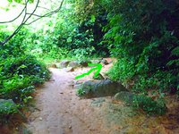
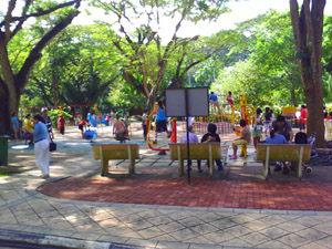
From Youth park, look for the children's playground. You won't miss it. is is very easy to find.

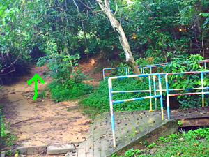
Across the playground, you should be able to see a small set of steps next to a signboard indicating the trailhead. Proceed up the steps, this is the begining of the trail. Take extra care when going up as the steps as it is a bit mossy and might be slippery.

Directions:
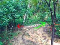
Recommended directions are indicated by the green arrow.
After going up the steps you will encounter the first junction of the trail (1). (the first part of the trails are full with forks and merges. So it will be a bit tricky.) On the right is a small bridge and on the left is a small path up. Follow the path up. The trail connecting to the bridge will lead to another trailhead at the bottom of the hill.
As soon as you go up the path, you will see another fork at the trail (2). The left will seem to open up to a small clearing. This is a short cut that will connect to the trail up ahead. It's a bit tough and not recommended for the inexperienced. Take the path on the right. Be careful as the branches are a bit low.
Then, you'll come to the next fork (3). this is a fairly straightforward one. Take the steps on the left.
(1) (2) (3)


After the first set of steps, is the next fork (4). Continue with the steps. When you have reached the top to the 2nd set of steps, there will be a straight path.
Follow that path and you will reach to a right turn (5). That turn merges (red arrow) with another trail from the left. I think that is the trail where a guy got lost in 2005 and was eventually found dead after a few days.
(4) (5)

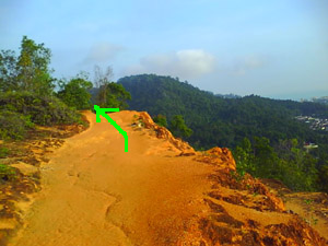
After the fork in (5) the trail is pretty straight forward it will be a single track for about 5-8 minutes walk with a small clearing in between.
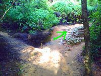
If you are still on the trail up, the next landmark you will encounter is this set of poles (6)(yellow + blue). The poles are actually barriers set up to prevent mountain bikers bacause, it will be one long fall into the nether world if you have the misfortune to fall into the gorge on the left.
After the barriers, there will be a sequence of 2 successive forks (7) & (8). The the left path on both forks.
(6) (7) (8)


By now, you can almost see the no.3 rest stop.
After the last fork at (8) you will come to a point where there is a set of very steep steps on the left of the path (9). The set of steps will lead directly to the no.3 rest area. Take the less strenous path on the right. Believe me, it will be worth it.
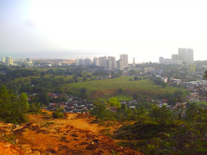
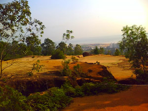
After a short walk you will reach a clearing (10). There, you will be rewarded with a stunning scenery of the north eastern part of penang island.
(9) (10)

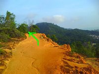
A sample of the view from the point (10)
After the clearing, just follow the path and you will reach no.3 rest area.. Here are some shots. I did not get any of the scenery as the dinky phone camera cannot capture well inthe bright sunlight.


If you go in the weekend afternoons, there will be drinking water. It used to be a very popular place. People even banded up to cook noodles for the hikers. But unfortunately the cooking thing stopped.
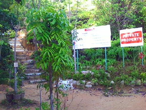
Another thing to note too is that the no.3 rest area actually sits on a private land. The owners have been nice enough to continue to let the hikers use the trail, but have put up a notice to remind the hikers that it is a private land that they are on.

There is also a toilet at no.3. So if you have been holding your wee wee, it's a good opportunity to relieve yourself.

Well, that's the directions to no.3. should be a fairly easy hike with a nice scenery at the end of the trail.
Will post directions to no.5 in later entries.
*Disclaimer:
Mind you that the directions are just for referance and should not be followed blindly. New paths do open up, trails do get overgrown, conditions do change so do top up with a fair bit of common sense when going up the trails. I must also warn that people have got lost (and lost their lives before) so do stick to the existing trail. I cannot and will not hold responsibility for if anything untoward should happen.
I am not sure why the res stops are named in those numbers but from what i heard it has something to do with topological markers or something.
Anyway, last weekend i hiked up to no.5, stopping at no.3 along the way.
For those interested to hike this trail, i have documented a pictorial direction. for this first part, i'll give the directions* to no.3. The trail up to no.3 is considered easy hike and can be achieved in less than 30 mins (one way). At the end of No.3 you will be rewarded with the view of the north east of the island.
Trailhead:
There are other alternative trailheads, but i'll show the most common one here.
From Youth park, look for the children's playground. You won't miss it. is is very easy to find.
Across the playground, you should be able to see a small set of steps next to a signboard indicating the trailhead. Proceed up the steps, this is the begining of the trail. Take extra care when going up as the steps as it is a bit mossy and might be slippery.

Directions:
Recommended directions are indicated by the green arrow.
After going up the steps you will encounter the first junction of the trail (1). (the first part of the trails are full with forks and merges. So it will be a bit tricky.) On the right is a small bridge and on the left is a small path up. Follow the path up. The trail connecting to the bridge will lead to another trailhead at the bottom of the hill.
As soon as you go up the path, you will see another fork at the trail (2). The left will seem to open up to a small clearing. This is a short cut that will connect to the trail up ahead. It's a bit tough and not recommended for the inexperienced. Take the path on the right. Be careful as the branches are a bit low.
Then, you'll come to the next fork (3). this is a fairly straightforward one. Take the steps on the left.
(1) (2) (3)


After the first set of steps, is the next fork (4). Continue with the steps. When you have reached the top to the 2nd set of steps, there will be a straight path.
Follow that path and you will reach to a right turn (5). That turn merges (red arrow) with another trail from the left. I think that is the trail where a guy got lost in 2005 and was eventually found dead after a few days.
(4) (5)


After the fork in (5) the trail is pretty straight forward it will be a single track for about 5-8 minutes walk with a small clearing in between.
If you are still on the trail up, the next landmark you will encounter is this set of poles (6)(yellow + blue). The poles are actually barriers set up to prevent mountain bikers bacause, it will be one long fall into the nether world if you have the misfortune to fall into the gorge on the left.
After the barriers, there will be a sequence of 2 successive forks (7) & (8). The the left path on both forks.
(6) (7) (8)


By now, you can almost see the no.3 rest stop.
After the last fork at (8) you will come to a point where there is a set of very steep steps on the left of the path (9). The set of steps will lead directly to the no.3 rest area. Take the less strenous path on the right. Believe me, it will be worth it.
After a short walk you will reach a clearing (10). There, you will be rewarded with a stunning scenery of the north eastern part of penang island.
(9) (10)

A sample of the view from the point (10)

After the clearing, just follow the path and you will reach no.3 rest area.. Here are some shots. I did not get any of the scenery as the dinky phone camera cannot capture well inthe bright sunlight.


If you go in the weekend afternoons, there will be drinking water. It used to be a very popular place. People even banded up to cook noodles for the hikers. But unfortunately the cooking thing stopped.
Another thing to note too is that the no.3 rest area actually sits on a private land. The owners have been nice enough to continue to let the hikers use the trail, but have put up a notice to remind the hikers that it is a private land that they are on.
There is also a toilet at no.3. So if you have been holding your wee wee, it's a good opportunity to relieve yourself.

Well, that's the directions to no.3. should be a fairly easy hike with a nice scenery at the end of the trail.
Will post directions to no.5 in later entries.
*Disclaimer:
Mind you that the directions are just for referance and should not be followed blindly. New paths do open up, trails do get overgrown, conditions do change so do top up with a fair bit of common sense when going up the trails. I must also warn that people have got lost (and lost their lives before) so do stick to the existing trail. I cannot and will not hold responsibility for if anything untoward should happen.
Labels: hiking
posted by Duckie at
3:00 PM
![]()
